Application Description
City routes, live traffic, transit routes, parking, offline map, and navigation.
We're excited to announce that we've updated 2GIS! The current version of the app had become challenging to showcase all the comprehensive information we gather about cities and businesses. In the new 2GIS, we've revamped the design, introduced a new search function, enhanced the city update process, and integrated favorites with 2gis.ru.
Services, addresses, and companies
2GIS provides detailed insights into which service providers operate in your building, and locates district hospitals or post offices near you. It assists in selecting cafes or service centers based on reviews and photos, and displays their opening hours and contact numbers.
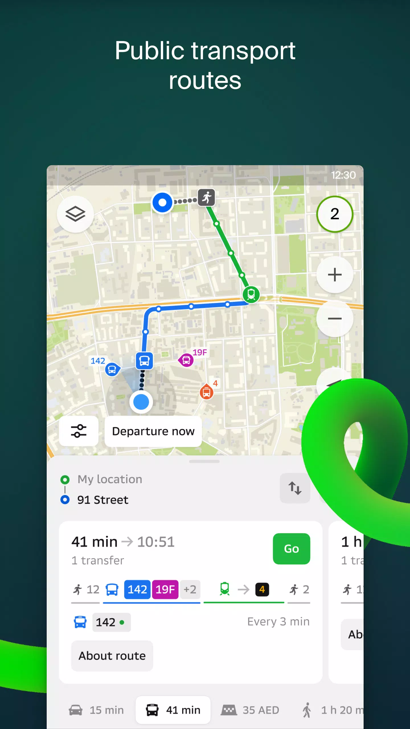
Transport and navigation
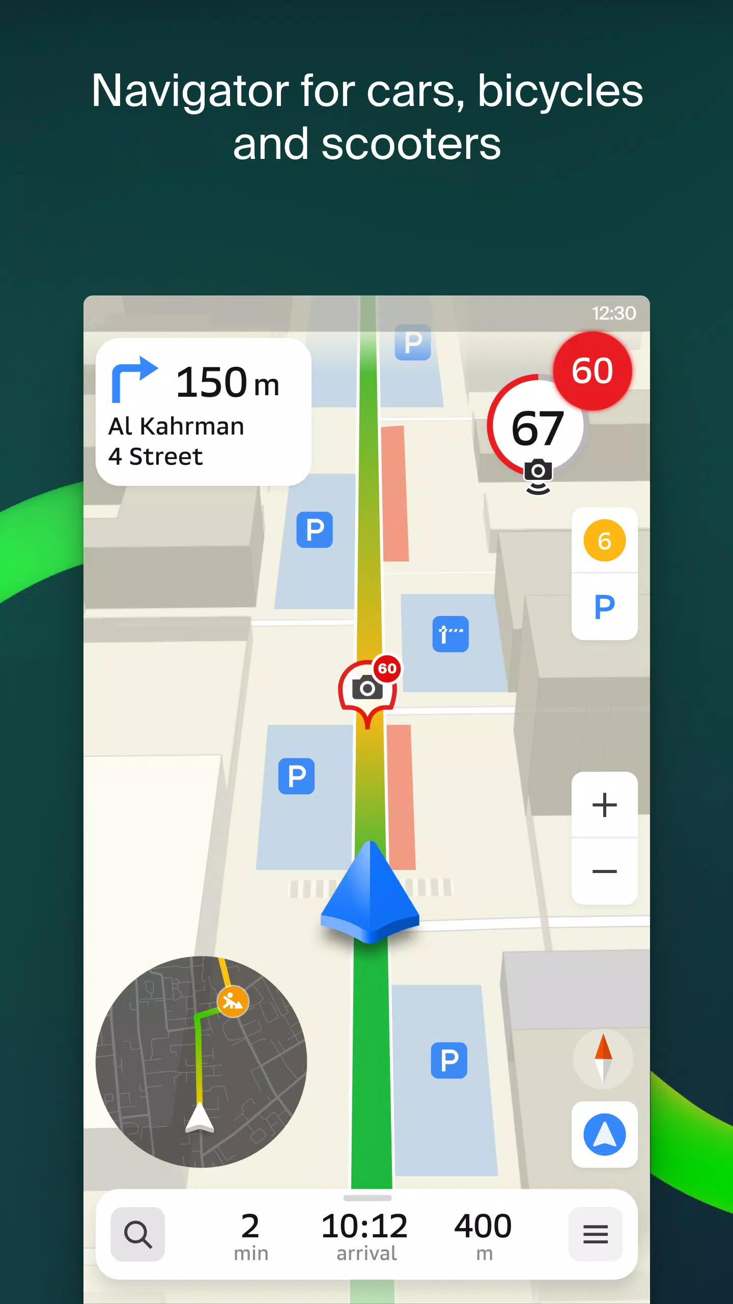
For drivers, 2GIS offers real-time navigation with voice-guided instructions, taking into account traffic congestion and road closures. It dynamically reroutes if you stray from your planned path. For pedestrians, it suggests travel options using buses, metro, trains, cable cars, and river trams.
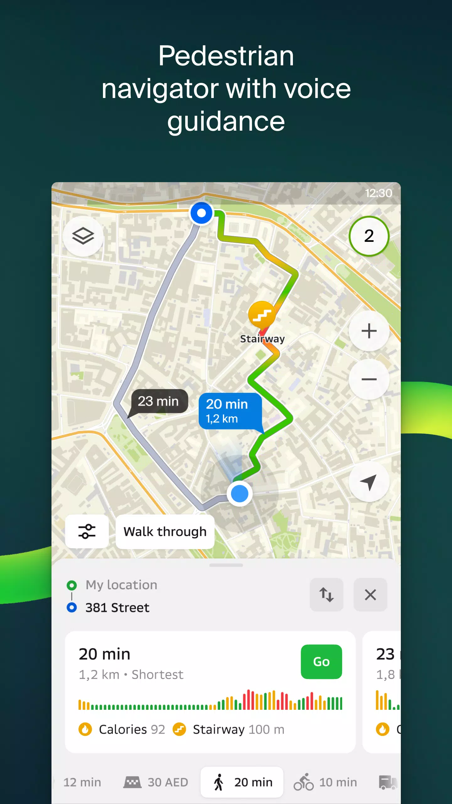
Walking routes
Our pedestrian navigation guides you wherever you can walk, operating seamlessly in the background with voice guidance.
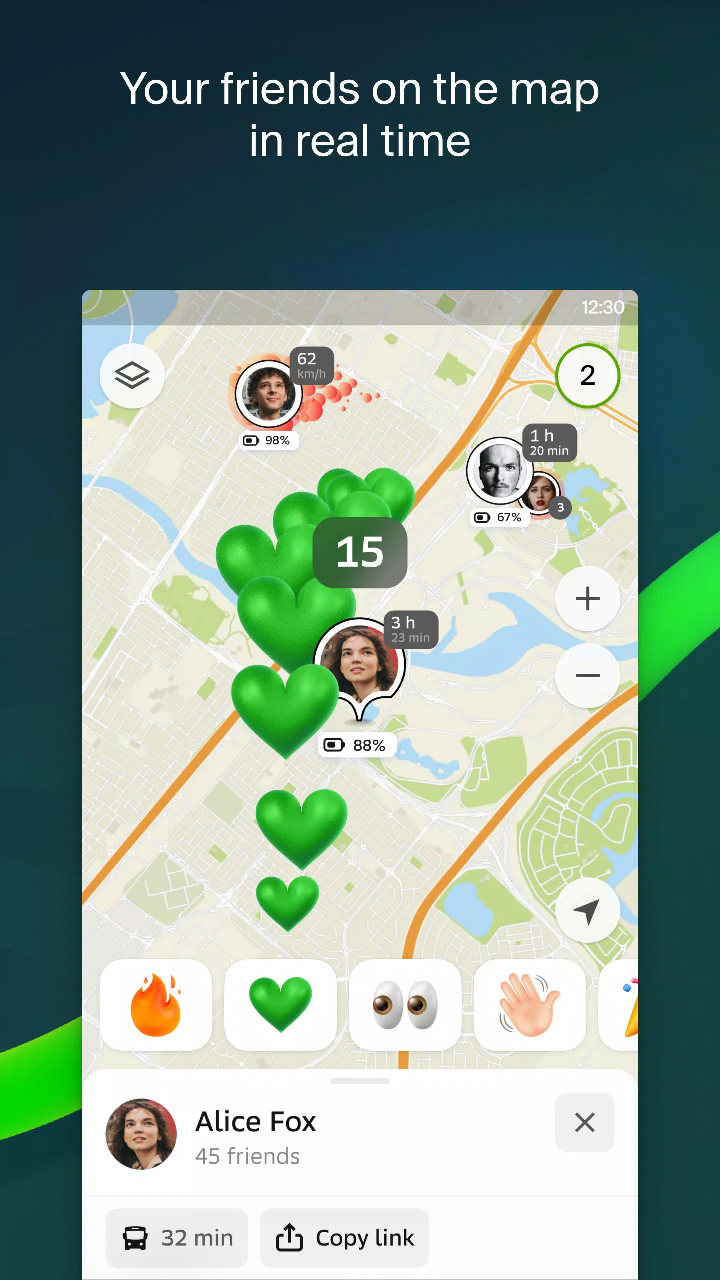
Friends on the map
Now, you can track your friends and children in real-time on the map! 2GIS allows you to manage who can see your location and who you can see, with customizable privacy settings.
Building entrances
Avoid the hassle of searching for entrances to business centers with 2GIS. The app provides entry points for 2.5 million companies, guiding you directly to the door whether you're traveling by public transport or car.
Plans of shopping centers
Navigate inside shopping centers effortlessly with 2GIS. It displays everything from stores and cafes to ATMs and restrooms, helping you plan your visit in advance to save time.
2GIS beta Notifications companion app for smartwatches on Wear OS
We've introduced a companion app for smartwatches running Wear OS 3.0 or later. This handy tool lets you navigate routes on foot, by bike, or public transport directly from the main 2GIS beta app. View maps, receive maneuver hints, and get vibration alerts as you approach turns or destination bus stops. The companion app starts automatically when you initiate navigation on your phone.
By using the beta version, you'll be among the first to receive updates as we fix bugs and errors, contributing to the development of the new 2GIS, soon to be used by millions. You can run both the original and beta versions simultaneously, switching between them as needed.
Support: [email protected]
What's New in the Latest Version 6.44.1.559.3
Last updated on Oct 19, 2024
Experience our latest, visually stunning updates: — Enhanced visuals with wide, realistic roads on the main map and during route searches. — Introducing Chats for Friends! Stay connected with in-app messaging without leaving the map. — New notifications when friends are nearby, which you can disable in settings. — Timely for ski enthusiasts: we've added ski lift status updates on slopes. — For mixed-mode commuters, we now calculate walking segments in steps when your public transport route includes walking.
Screenshot
Reviews
Post Comments
Latest Articles

Mutants: Genesis Hits iOS, Android, Steam After Early Access
Clash Royale players finally get to witness the highly anticipated evolution of the Inferno Dragon. After nearly a decade without an upgrade, this fiery Legendary card receives a powerful transformation. The developers at Supercell teamed up with Fin

Pokemon GO Road Trip 2025 Details, Summer Pikachu Available
Experience Pokémon GO Road Trip Truck stops in the gameFind Wooloo, Phanpy, and Alolan Geodude in the wildSummer-style Pikachu makes a special appearanceIf today's new details don't get you excited for the Pokemon GO Road Trip 2025, nothing will. Thi

PlayStation Stars Shuts Down After 3 Years
Sony has announced the discontinuation of its PlayStation Stars loyalty program less than three years after its introduction.The rewards initiative stopped accepting new members today, with exiting participants unable to rejoin. Canceling membership
Mastering Cooking in Ragnarok X: Next Generation
Cooking in Ragnarok X: Next Generation is a dynamic system that enhances combat, resource gathering, and character progression. Preparing dishes grants temporary boosts, improving dungeon survivabilit

Poppy Playtime Chapter 4 Launches with Introductory Sale
Uncover new characters and a deeper backstoryNavigate the depths of the Playtime Co. factoryLimited-time introductory discount availableMob Entertainment has officially released Poppy Playtime Chapter 4, allowing you to dive into the next chilling ch
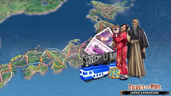
Japan Expansion for Ticket to Ride: Build the Bullet Train Network!
Ticket to Ride now lets you embark on a virtual train journey across Japan with its latest expansion. Marmalade Game Studio and Asmodee Entertainment have launched the Japan Expansion for their digital adaptation of the classic board game.
Help Build
Apps like 2GIS beta


台北捷運Go
Maps & Navigation丨96.5 MB


Crawfisher LE
Maps & Navigation丨33.1 MB

Kigo - Parkimovil
Maps & Navigation丨42.8 MB


BP Fatár
Maps & Navigation丨3.6 MB
GO Sharing
Maps & Navigation丨83.0 MB

Red Taxi
Maps & Navigation丨22.5 MB
Latest Apps

Lola Casademunt
Shopping丨6.8 MB

Anime Chicken
Tools丨38.90M

WashAssist Dashboard
Lifestyle丨11.70M


FUNNY PICKUP LINES
Lifestyle丨7.10M

HANGOVER VPN
Tools丨29.10M


Trending Apps
MORE +


Top News
MORE +

01
01-06
CDPR acknowledged weak gameplay in The Witcher 3
The Witcher 3, while critically acclaimed, wasn't without its flaws. Many fans felt the combat system fell short.
In a recent interview, Witcher 4's game director, Sebastian Kalemba, acknowledged weaknesses in the previous game's gameplay, specifically highlighting the need for significant improvem
02
01-07
BREAKING: Flight Simulator 2024 Login Woes Ground Players
Flight Simulator 2024 Launch Plagued by Technical Difficulties
The highly anticipated launch of Flight Simulator 2024 has been significantly hampered by widespread technical problems, leaving many players grounded before they could even take to the virtual skies. This article details the reported d
03
11-17
Hogwarts Legacy 2 is "One of the Biggest Priorities" for WB Games
Following the successful launch of Quidditch Champions this week, Warner Bros. Discovery has confirmed its plans for a sequel to last year's Harry Potter-based action RPG hit Hogwarts Legacy—2023's best-selling game.Hogwarts Legacy Sequel Plans Confirmed by Warner Bros. DiscoveryExpected in
04
11-16
Airplane Chefs Brings The Ultimate Snack, Pringles, On Board!
Buckle up for some snacks as Nordcurrent has just dropped an exciting event for their cooking game. It’s the most unexpected collab of Airplane Chefs and Pringles. If you’ve been enjoying your virtual life as a flight attendant, things are about to get a lot tastier.The game developer behind p
05
11-16
Play Together to collaborate with Sanrio and introduce new My Melody and Kuromi content
Play Together is bringing back its Sanrio collab with the appearance of My Melody and KuromiYou can collect coins by completing their themed missions that can then be used to draw exclusive itemsAs a bonus there's also new summer-themed content and events, including a major bug huntPlay Together, th
Topics
More +