Application Description
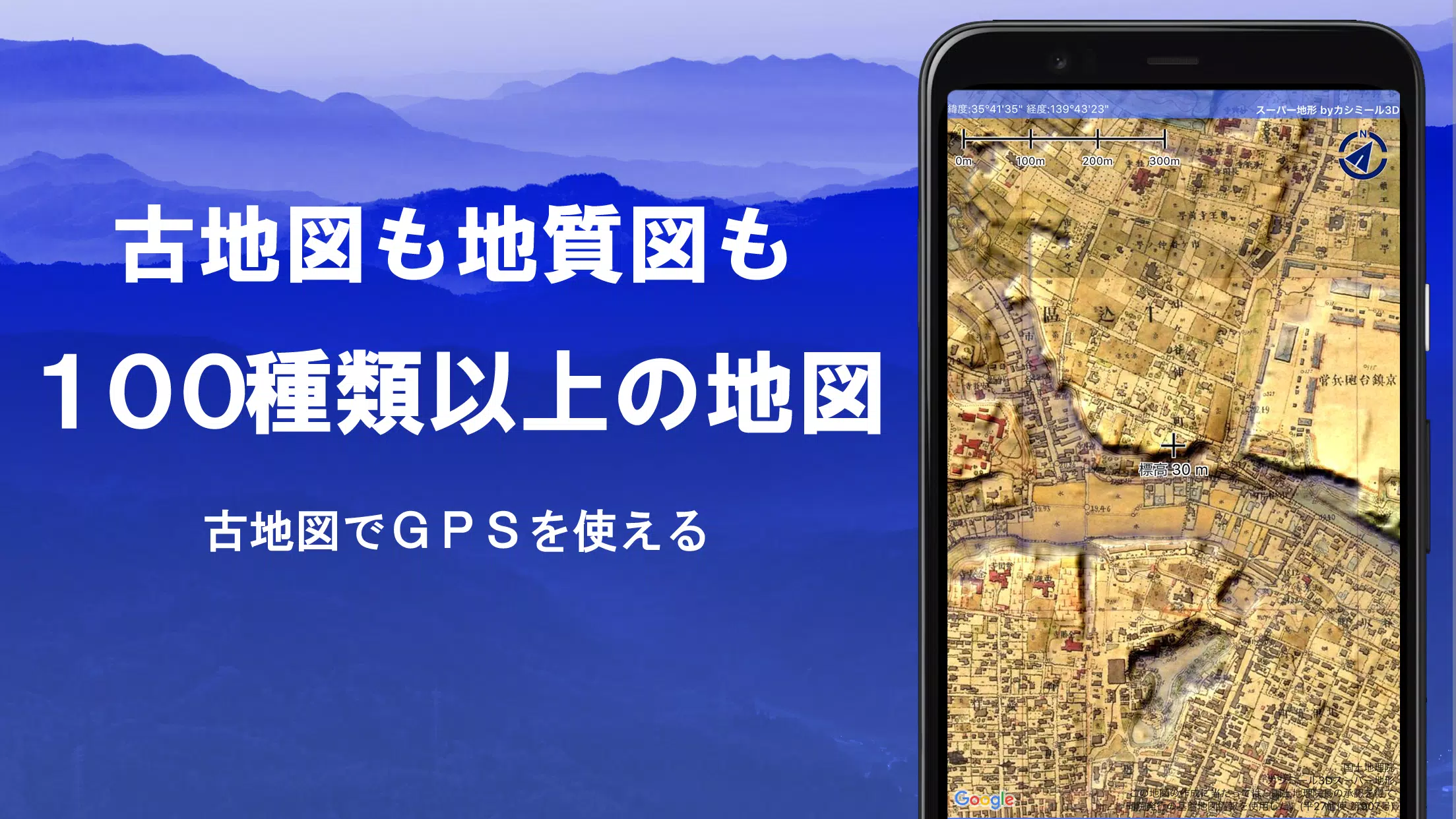
Discover a world of exploration with more than 100 types of maps at your fingertips, including those from the Geographical Survey Institute. These maps are perfect for everything from mountain climbing to leisurely strolls around town, leveraging the height differences to enhance your journey. Our app was honored with the 2018 Japan Cartographic Society Award for Best Work, reflecting its excellence and utility.
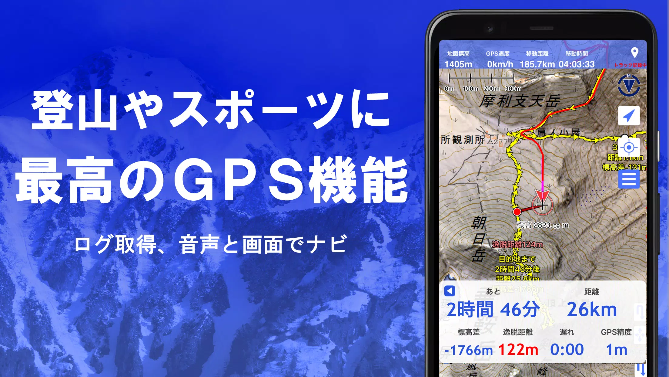
Dive into the "super terrain data," a unique technology that vividly emphasizes terrain details. Access maps from the Geospatial Information Authority of Japan, including topographic, geological, old, past and present, and prewar topographic maps from the Ordnance Survey Department. Utilize your device's GPS function to record tracks (trajectories), and enjoy GPX log input/output and editing capabilities. Our app is equipped with functions to support walking around town, mountain climbing, and various outdoor activities, including GPS navigation with audio guidance, data recording, and editing.
Enhance your planning with the visibility determination function, useful for creating cross-sectional diagrams, observing landscapes, and assessing radio signal coverage. This feature can also display buildings, providing a comprehensive view of your surroundings. Additionally, the 360° panoramic view function enables mountain identification, allowing you to learn the names of mountains effortlessly. You can also display the sun, moon, and GPS points for a more immersive experience.
Experience seamless outdoor adventures with our GPS function, bulk map download, and map cache features, ensuring you stay on course even without a radio signal. Associate photos with specific points, display contour lines generated from elevation data, and view MGRS (UTM) grids for precise navigation. Our app supports reading, displaying, and editing GIS data from GeoJSON files, and you can draw shapes to mark your findings. Whether you're at home or abroad, our map printing and PDF output functions are at your disposal, and you can switch to a dark theme for a more comfortable viewing experience.
1. A Wealth of Maps at Your Disposal
Explore a variety of maps, with over 100 types to choose from, including our exclusive super topographic data and maps from the Geospatial Information Authority of Japan. Note that aerial photographs may have limited coverage depending on the age group, with the "Latest" and "around 1974" categories offering the widest coverage. Enjoy a free 5-day trial of the super terrain data map upon installing the app.
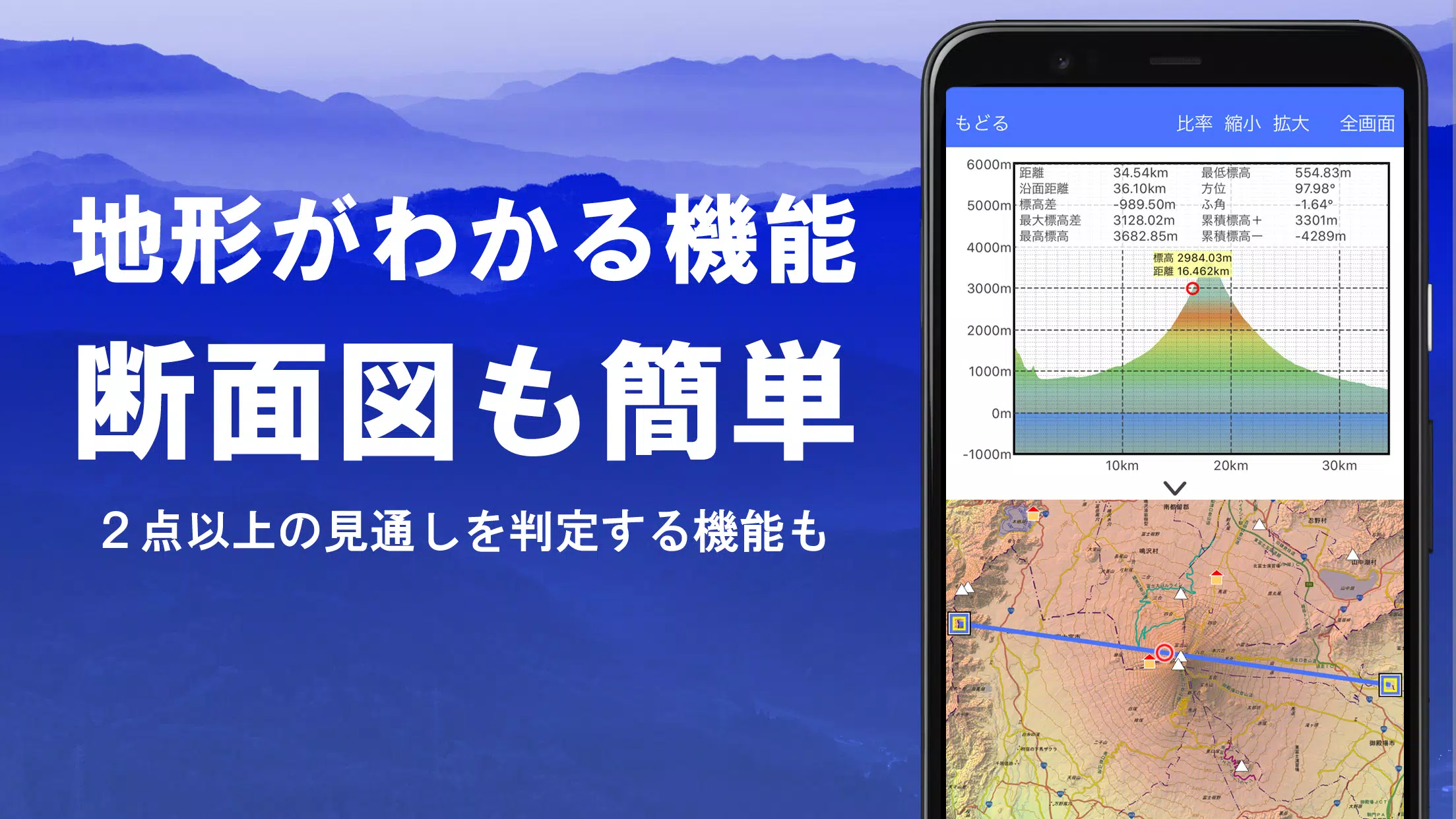
2. Creating Cross Sections and Outlooks
Effortlessly draw cross sections through any point on the map, utilizing the visibility judgment function from Kashmir 3D. Our calculations consider the Earth's curvature and atmospheric variations, aiding in route planning for climbing, assessing wireless visibility, and understanding terrain. Where PLATEAU building data is available, incorporate buildings into your cross-sectional views.
3. Elevation Palette Function
Customize your map's appearance with the elevation palette function, allowing you to change the background color to your preferred gradient in 1cm increments.
4. Panoramic View
Experience panoramic observation maps that reveal mountain names from any point on the map. With a 360° panorama linked to your smartphone's compass, you can easily identify mountains. Display the sun and moon, including moon phases, to explore phenomena like Diamond Fuji and Pearl Fuji. View GPS point locations and draw panoramic views of mountains worldwide.
5. GPS Function
Leverage your smartphone's GPS for accurate location tracking and record your routes. Our high-precision positioning is ideal for serious mountain climbing and outdoor activities. View graphical representations of your tracks with parameters like elevation changes, speed, time, and elapsed time. The point alarm function alerts you with voice and sound when you approach designated points. Display photos linked to specific points and send the map center position to NaviCon.
6. GPS Track Summary Playback
Replay your track logs comprehensively, with the app automatically matching and displaying photos based on their shooting times. Tap the icon at the photo location to view them.
7. GPS Navigation Function
Navigate along preset tracks using the Track Navi feature, with voice or alarm alerts if you deviate from your route. This ensures you stay on course during climbs. Additionally, use route navigation for urban strolls and point navigation to reach specific locations.
8. GPS Data Editing Function
Manage GPS-related point, route, and track data, organizing them into folders and displaying them in an easy-to-read tree format. Create tracks directly on the map and import or export data in GPX format from mountain climbing sites.
9. Map Usage Outside the Service Area (Offline)
Use maps even in signal-free areas, such as during mountain climbing, thanks to the bulk download function that ensures all scale maps of a specified plot are available. Easily monitor what's being downloaded to avoid map shortages on-site, and utilize the cache function for seamless access.
10. Map History Function
The app remembers locations you've viewed, allowing you to return to them quickly.
11. Custom Map Compatibility
Import and use custom maps cut with Kashmir 3D's map cutter, displaying your own maps and scanned images. When using the map cutter, divide images into approximately 256 x 256 pixels and send the resulting kmz file to Super Terrain via email or Cloud Drive.
12. GeoJSON Compatibility
Display and edit points, linestrings, and polygons from GeoJSON format files, and draw new shapes to mark your discoveries.
13. Print/PDF Output
Print any area of the map at a specified scale or create a PDF for your records.
14. Cooperation with Other Apps
Input and output GPS data in GPX, KML, and GDB formats, facilitating data exchange with other apps, Kashmir 3D on your PC, and trajectory data from mountain climbing sites.
15. Backup Function
Backup all app data (excluding cached maps) and store it off your smartphone. Restore data even if the app is deleted or your device malfunctions. Use the automatic backup feature with Google Drive to maintain up-to-date backups. For detailed instructions, refer to the manual.
16. About Billing Function
Some features, including maps using super terrain data, GPS track functions, and cross-sectional views, require in-app purchases. After payment, you'll enjoy increased search results for place name queries.
●Fees: Annual payment of 780 yen/year.
●Free Trial: Experience the app for free for 5 days after installation. Post-trial, some features and maps will be unavailable unless you purchase them. You will not be charged without a purchase action. To purchase, navigate to [Settings] - [Purchase to remove functional restrictions] within the app.
●Confirmation and Cancellation: Check or cancel automatic updates via Google Play: 1) Open Google Play, 2) Select "Regular Purchase" from the menu, 3) Choose "Super Terrain."
●Price Revision: Prices may change due to future enhancements. Early purchase is beneficial.
17. Terms of Use
The copyright holder and developer are not responsible for the outcomes of using this app. Upon first GPS use, allow location information services when prompted. Note that continuous GPS use will drain your battery, so carry a spare if your device is also used for emergency communication. For an in-depth explanation of the navigation function, refer to the PDF at https://www.kashmir3d.com/online/superdemapp/superdem_navi.pdf.
Some smartphones may experience interruptions or failures in track recording due to power-saving features forcibly closing background apps. A workaround is to keep the screen on while using Super Terrain, but this isn't a permanent solution.
Screenshot

Reviews
Post Comments
Latest Articles

Borderlands 4 for Switch 2 Releases Feb 27, Suggests Retailer Listing
A retailer listing indicates that the Nintendo Switch 2 version of Borderlands 4 is scheduled for release on February 27. Continue reading to discover additional details, ranging from PC performance challenges to the Switch 2 launch postponement.Bor

Felt it after a century ride Crossword Clue - Try Hard Guides
We’ve found the 5-letter solution for the "Felt it after a century ride" crossword clue, which appeared in the USA Today Crossword puzzle dated May 14, 2026. Occasionally, we all need a little assistance cracking these puzzles!Felt it after a century
Yōtei Ghost Cinematic Filters Customize Game Vibe
Ghost of Yōtei is designed to evoke the feel of classic samurai cinema through its in-game visual filters and modes, offering a deeply immersive atmosphere. Continue reading to learn more about how the game creates a vivid, cinematic adventure.Ghost
MTG's Edge of Eternities Sold Out at Amazon on Launch
Magic: The Gathering enthusiasts have been counting down to their journey through the Blind Eternities, and the moment has finally arrived. Edge of Eternities officially launched worldwide today, bringing cosmic-scale fantasy to the classic trading c

LEGO Spider-Verse Minifigures Available for Preorder
LEGO is launching an exciting array of new sets this season, but if you're only looking to expand your minifigure collection, the company has a pleasant surprise in store next month. Starting September 1, LEGO will release a blind box of Spider-Man:

Spin Rhythm XD Is Coming to Mobile Soon on the Crunchyroll Game Vault
You may know developer Super Spin Digital for titles like Fruit Ninja, Jetpack Joyride, and Steppy Pants. Another one of their popular releases is the rhythm game Spin Rhythm, whose success paved the way for its sequel, Spin Rhythm XD, which launched
Apps like スーパー地形 - GPS対応地形図アプリ


台北捷運Go
Maps & Navigation丨96.5 MB
Crawfisher LE
Maps & Navigation丨33.1 MB

Kigo - Parkimovil
Maps & Navigation丨42.8 MB

BP Fatár
Maps & Navigation丨3.6 MB

GO Sharing
Maps & Navigation丨83.0 MB

Red Taxi
Maps & Navigation丨22.5 MB

ØstfoldReise
Maps & Navigation丨4.5 MB
Latest Apps

Учи.ру 0–4 класс
Education丨12.8 MB

에스크 asked
Communication丨18.30M


Spiga+ AI
Auto & Vehicles丨12.0 MB


Epoxy Resin Art Ideas
Art & Design丨41.0 MB

Lola Casademunt
Shopping丨6.8 MB

Anime Chicken
Tools丨38.90M

WashAssist Dashboard
Lifestyle丨11.70M
Trending Apps
MORE +


Top News
MORE +

01
01-06
CDPR acknowledged weak gameplay in The Witcher 3
The Witcher 3, while critically acclaimed, wasn't without its flaws. Many fans felt the combat system fell short.
In a recent interview, Witcher 4's game director, Sebastian Kalemba, acknowledged weaknesses in the previous game's gameplay, specifically highlighting the need for significant improvem
02
01-07
BREAKING: Flight Simulator 2024 Login Woes Ground Players
Flight Simulator 2024 Launch Plagued by Technical Difficulties
The highly anticipated launch of Flight Simulator 2024 has been significantly hampered by widespread technical problems, leaving many players grounded before they could even take to the virtual skies. This article details the reported d
03
11-17
Hogwarts Legacy 2 is "One of the Biggest Priorities" for WB Games
Following the successful launch of Quidditch Champions this week, Warner Bros. Discovery has confirmed its plans for a sequel to last year's Harry Potter-based action RPG hit Hogwarts Legacy—2023's best-selling game.Hogwarts Legacy Sequel Plans Confirmed by Warner Bros. DiscoveryExpected in
04
11-16
Airplane Chefs Brings The Ultimate Snack, Pringles, On Board!
Buckle up for some snacks as Nordcurrent has just dropped an exciting event for their cooking game. It’s the most unexpected collab of Airplane Chefs and Pringles. If you’ve been enjoying your virtual life as a flight attendant, things are about to get a lot tastier.The game developer behind p
05
11-16
Play Together to collaborate with Sanrio and introduce new My Melody and Kuromi content
Play Together is bringing back its Sanrio collab with the appearance of My Melody and KuromiYou can collect coins by completing their themed missions that can then be used to draw exclusive itemsAs a bonus there's also new summer-themed content and events, including a major bug huntPlay Together, th
Topics
More +