Application Description
Are you looking for a streamlined way to manage your KML, KMZ, and GPX files? Do you need a robust GIS tool that also supports measuring, GPS logging, WMS, and offline maps? Look no further than MAPinr, the perfect solution for all your mapping needs.
Thank you for choosing MAPinr. The rapid evolution of Android versions poses a challenge for non-profit projects like ours. Despite this, we are committed to keeping MAPinr alive and aligned with our mission to offer a secure, privacy-focused, and affordable app.
We understand that Google requires a minimum Android version that many devices may not support. To address this, we provide downloads for older Android versions (below Android 14), which are no longer available on the Play Store, directly from our website.
Are you interested in managing your own points of interest or adding your photos to a map? MAPinr is the answer. This simple, ad-free Android app is designed to help you manage your KML/KMZ files and display your GPX files on various maps. Whether for professional use or recreational activities like hiking, cycling, running, or skiing, MAPinr is your go-to tool.
We value your feedback and suggestions for improving MAPinr. Please share your thoughts with us at [email protected]. We appreciate constructive feedback, as we understand that software bugs can be frustrating. Please be patient and understand that our limited resources may prevent us from implementing every suggestion.
MAPinr offers the following features:
- Ad-Free Experience: No intrusive ads to distract you.
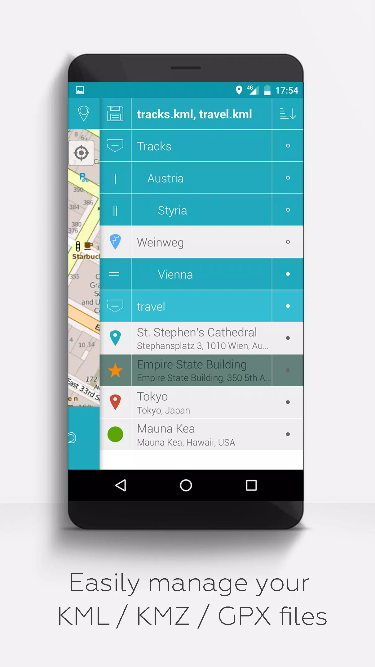
- Organized File Management: A hierarchical folder structure for managing multiple KML/KMZ/GPX files.
- Comprehensive File Operations: Create, load, edit, save, import, export, and share KML/KMZ files.
- Versatile Editing: Create, load, edit, save, import, export, and share waypoints, lines/tracks, and polygons.
- Photomap Creation: Add pictures to your waypoints to create personalized photomaps.
- Diverse Map Display: Show waypoints, lines/tracks, and polygons on various maps including Maps, Satellite, Hybrid, OpenStreetMap, Opentopomap, and Opencyclemap.
- Coordinate Sharing: Easily share the coordinates of your waypoints.
- Custom Colorization: Individually colorize waypoints, lines/tracks, and polygons for easy identification.
- Interoperability: Open exported KML/KMZ files in other apps.
- Advanced Search: Search by name, address, and coordinates.
- Location Sharing: Share your location with friends in real-time.
- Multi-File Support: Display multiple KML/KMZ/GPX files simultaneously.
- File Merging: Merge KML/KMZ files for comprehensive mapping.
- Cloud Integration: Seamlessly integrate with cloud services.
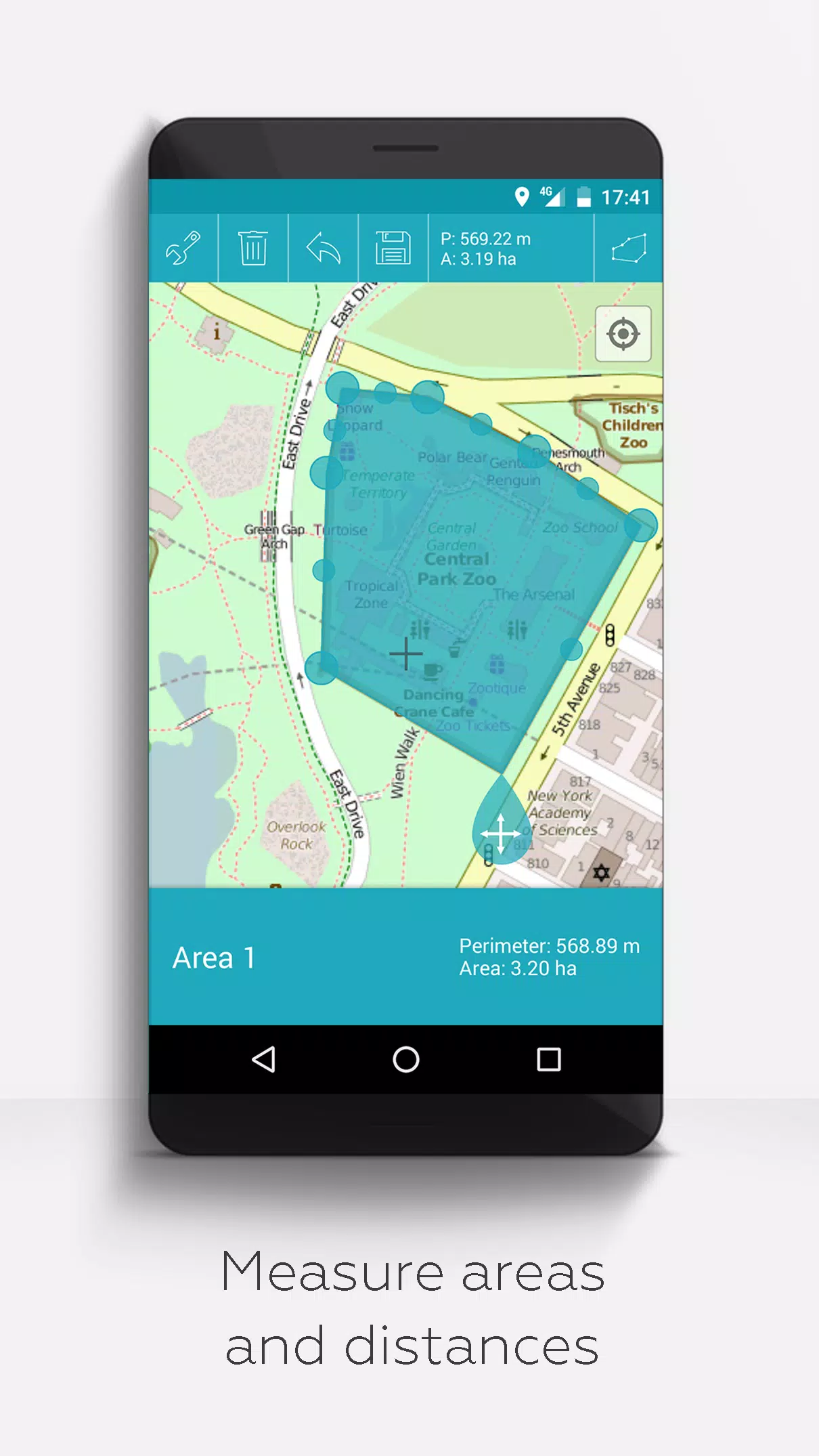
- Measurement Tools: Measure distances and areas directly on your map.
- Multilingual Support: Available in English, Spanish, Lithuanian, and Polish.
Unlock extended features for free with donations or by liking us on LinkedIn; these can be activated in the app's Settings:
- Offline Maps: Download maps for free from OpenStreetMap for use offline.
- GPX Viewer: Display GPX files (viewing only).
- WMS Support: Display arbitrary map data using Web Map Service (WMS), including open data from www.data.gov.
- Custom Metadata: Create custom metadata for your maps.
- Custom Icons: Upload and use your own icons.
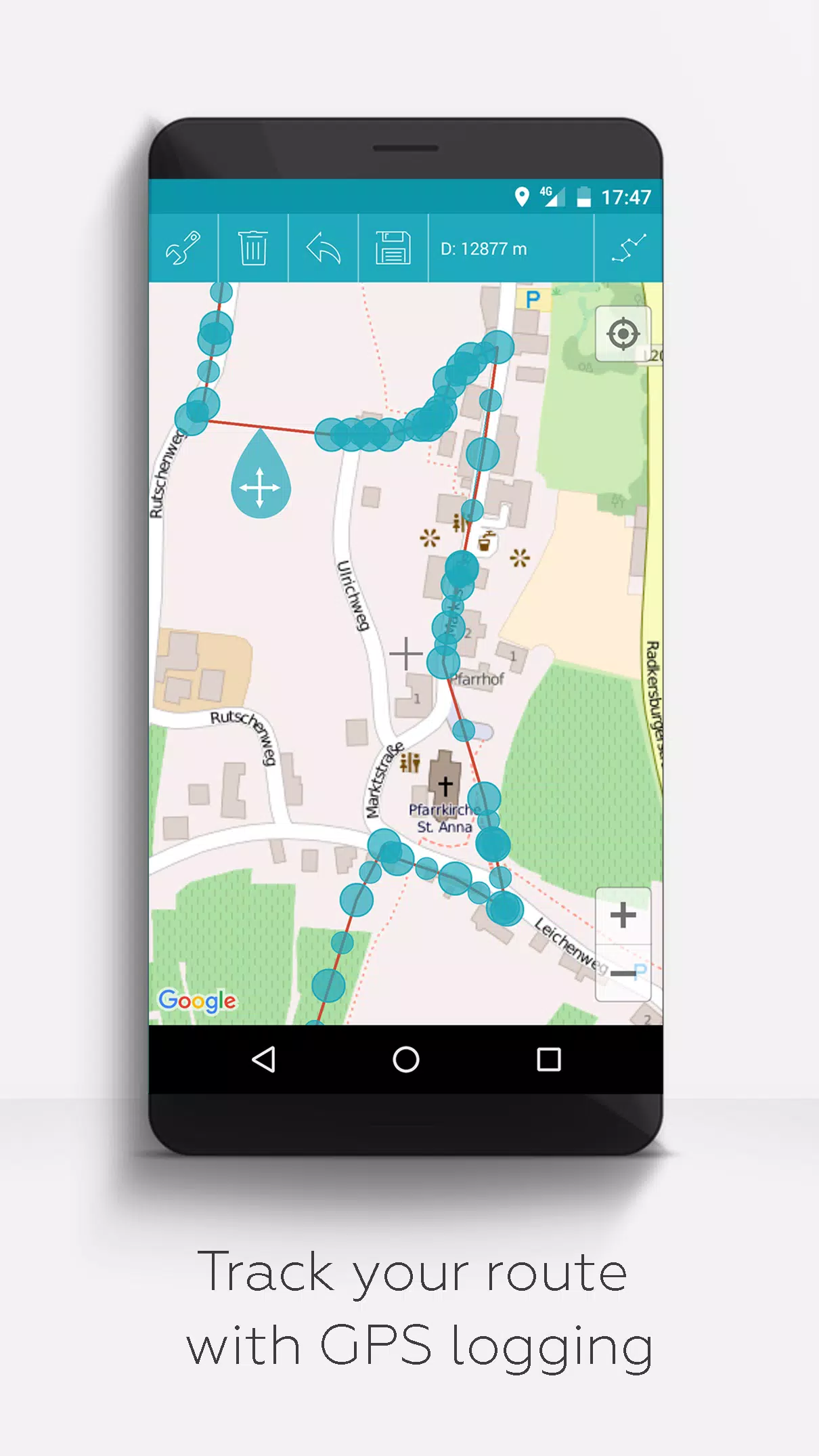
- GPS Logging: Record GPS tracks to document your journeys.
Unlike other apps, MAPinr respects your privacy and will never exploit your personal data. Donations are voluntary contributions to support our non-profit efforts.
Screenshot
Reviews
Post Comments
Latest Articles
MTG's Edge of Eternities Sold Out at Amazon on Launch
Magic: The Gathering enthusiasts have been counting down to their journey through the Blind Eternities, and the moment has finally arrived. Edge of Eternities officially launched worldwide today, bringing cosmic-scale fantasy to the classic trading c
LEGO Spider-Verse Minifigures Available for Preorder
LEGO is launching an exciting array of new sets this season, but if you're only looking to expand your minifigure collection, the company has a pleasant surprise in store next month. Starting September 1, LEGO will release a blind box of Spider-Man:

Spin Rhythm XD Is Coming to Mobile Soon on the Crunchyroll Game Vault
You may know developer Super Spin Digital for titles like Fruit Ninja, Jetpack Joyride, and Steppy Pants. Another one of their popular releases is the rhythm game Spin Rhythm, whose success paved the way for its sequel, Spin Rhythm XD, which launched

Elden Ring Glitch Eases Item Sharing in Nightreign
Elden Ring Nightreign features some incredible gear drops. There may even be times when you wish to share this equipment with others, while still keeping it for yourself. Fortunately, a gear duplication glitch makes sharing this loot possible, at lea
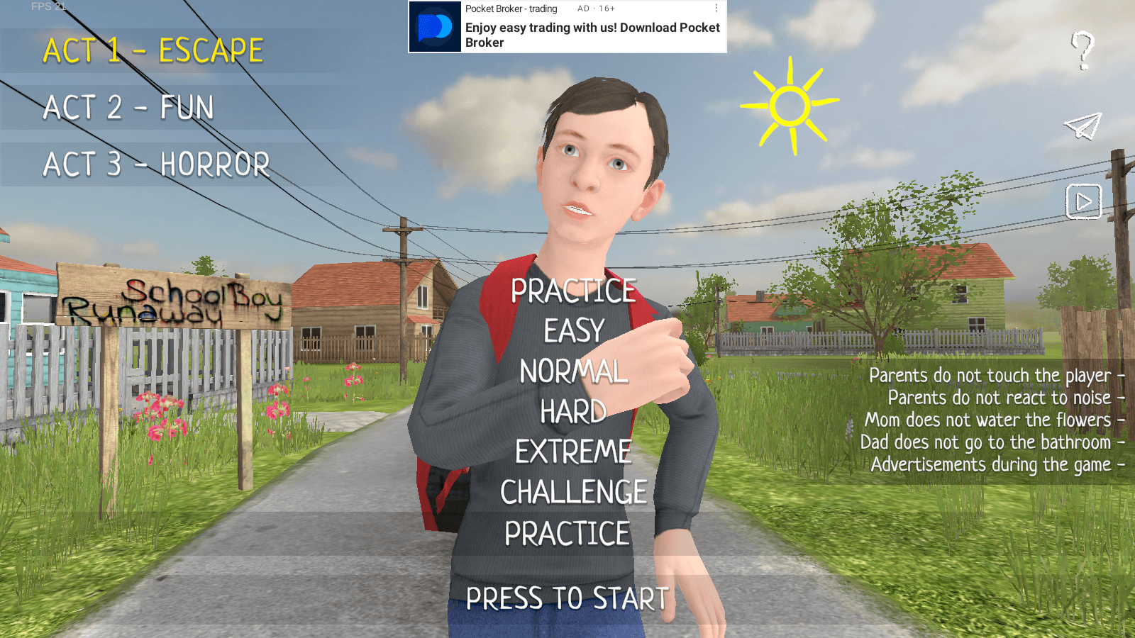
Master Stealth Tactics in SCHOOLBOY RUNAWAY
SCHOOLBOY RUNAWAY – STEALTH delivers thrilling stealth gameplay where you play as a mischievous student who'd rather sneak out than hit the books. Carefully evade your watchful parents using clever tactics and everyday household items to execute your
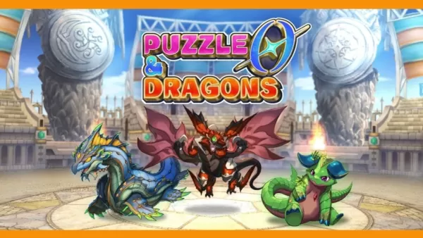
Puzzle & Dragons 0 Launches on Android with Innovative Root Tree System
Puzzle & Dragons 0 is now available, offering a fresh take on matching orbs and defeating monsters. Developed by GungHo Entertainment, the team behind the original mobile hit, this new entry reimagines the beloved puzzle-RPG experience.
What’s New in
Apps like MAPinr - KML/KMZ/OFFLINE/GIS
Pass2Park it Guest
Travel & Local丨59.50M


StaffTraveler
Travel & Local丨26.30M

Tivoli Gardens
Travel & Local丨57.90M


Trivio
Travel & Local丨11.10M

Scandic Hotels
Travel & Local丨68.20M
Latest Apps

에스크 asked
Communication丨18.30M


Spiga+ AI
Auto & Vehicles丨12.0 MB


Epoxy Resin Art Ideas
Art & Design丨41.0 MB

Lola Casademunt
Shopping丨6.8 MB

Anime Chicken
Tools丨38.90M

WashAssist Dashboard
Lifestyle丨11.70M

Trending Apps
MORE +


Top News
MORE +

01
01-06
CDPR acknowledged weak gameplay in The Witcher 3
The Witcher 3, while critically acclaimed, wasn't without its flaws. Many fans felt the combat system fell short.
In a recent interview, Witcher 4's game director, Sebastian Kalemba, acknowledged weaknesses in the previous game's gameplay, specifically highlighting the need for significant improvem
02
01-07
BREAKING: Flight Simulator 2024 Login Woes Ground Players
Flight Simulator 2024 Launch Plagued by Technical Difficulties
The highly anticipated launch of Flight Simulator 2024 has been significantly hampered by widespread technical problems, leaving many players grounded before they could even take to the virtual skies. This article details the reported d
03
11-17
Hogwarts Legacy 2 is "One of the Biggest Priorities" for WB Games
Following the successful launch of Quidditch Champions this week, Warner Bros. Discovery has confirmed its plans for a sequel to last year's Harry Potter-based action RPG hit Hogwarts Legacy—2023's best-selling game.Hogwarts Legacy Sequel Plans Confirmed by Warner Bros. DiscoveryExpected in
04
11-16
Airplane Chefs Brings The Ultimate Snack, Pringles, On Board!
Buckle up for some snacks as Nordcurrent has just dropped an exciting event for their cooking game. It’s the most unexpected collab of Airplane Chefs and Pringles. If you’ve been enjoying your virtual life as a flight attendant, things are about to get a lot tastier.The game developer behind p
05
11-16
Play Together to collaborate with Sanrio and introduce new My Melody and Kuromi content
Play Together is bringing back its Sanrio collab with the appearance of My Melody and KuromiYou can collect coins by completing their themed missions that can then be used to draw exclusive itemsAs a bonus there's also new summer-themed content and events, including a major bug huntPlay Together, th
Topics
More +